Content [Hide]
Krasnodar is located in the south-west of the country about 100 km from the Black and Azov Seas. It is located on the border of the temperate and subtropical climatic zones, which leads to long summers and relatively warm winters. What kind of winter will be affected by air masses that invade Krasnodar from the continent and from the Black Sea. In 2019-2020, significant disasters are not forecasted in winter, and temperature indicators will not have significant deviations from the standard level. A slight increase in average daily temperature is possible, since a similar trend has been observed for several years in a row.
Climate features
Krasnodar is located in the southernmost region of Russia. Local weather is not typical for most other constituent entities of the Russian Federation, since a subtropical climate prevails in the Krasnodar Territory. The warm air masses that come from the Black Sea provide stable heat throughout the year.
Since the city is located on the northern border of the subtropical climate zone with transition to moderate, the weather here is changeable. Arctic cyclones coming from the continent bring cold winds with them and help lower temperatures below zero. The Caucasus Mountains, which create an obstacle to their free movement, really show their abilities to the Arctic air masses.
Due to the peculiarities of the geographical location, severe frosts are rare in this area, and winters are mostly warm with a periodic drop in temperature below zero. Winter Krasnodar is characterized by the following weather conditions:
- average daily temperature + 5 ... + 10;
- rare snow that melts quickly;
- it often rains (sometimes mixed with snow);
- sudden changes in weather;
- strong winds;
- rare frosts (in this case, the temperature may drop below -10).
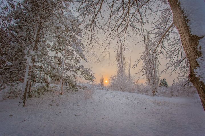
Winter weather forecast
It is difficult to say for sure what the weather will be like in Krasnodar in the winter of 2019-2020. Forecasters can make assumptions based on data from past years, comparing them with modern climatic conditions. In recent years, a significant increase in temperature has been observed, especially in the southern region. Scientists attribute this to global warming, which is common throughout the planet. In the past year, severe frosts were not observed in Krasnodar in winter, therefore, according to forecasts, they should not be this year either.
December 2019
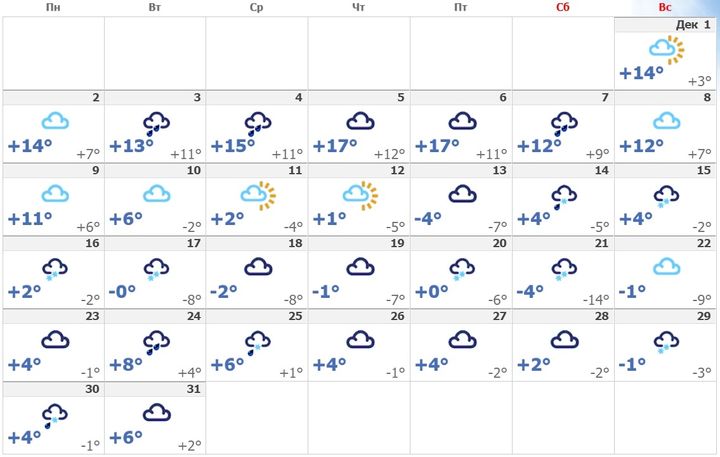
The first month of winter in Krasnodar is more like late autumn. The positive temperature confidently holds during the day, and at night the thermometer columns can drop to 0. This winter will come only at the end of the month, at its beginning it will be possible to observe the following temperature indicators:
- From December 01 to December 12, mostly warm weather is expected to be + 8 ... + 10 in the afternoon, and + 5 ... + 6 at night. Throughout the entire period of precipitation is not predicted, cloudiness with the infrequent appearance of the sun will prevail. The wind will increase from 6 m / s in the early days and up to 8 m / s by the 10th, so the weather will feel colder than the thermometer shows.
- From December 13 to December 21, the temperature will fluctuate from minus values to plus. Rains with gusts of 6-7 m / s are expected. Due to frequent precipitation and cold winds, the weather will feel like -1 ... + 1.
- From December 21 to December 31, at first several days of warming are expected to +7, after which a sharp cooling to +1 in the afternoon. At night, the thermometer bars will show -1 ... 0.Rainy weather will last until the end of the month.
January 2020
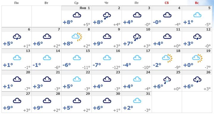
Frosts in Krasnodar begin in January. However, they cannot be called too strong. Over the past few years (analyzing data for four years), the maximum daytime temperature dropped to -11 in 2016. From 2017 to 2018, on average, daily minimums were -4 ... -8. And in 2019 in January on the coldest day it was 0 degrees. This indicates a clear trend towards warming. In 2020, the weather in January will be as follows:
- In the first two days of the new year, in the afternoon, the thermometers will show + 8 ... + 4, and at night + 4 ... + 5. From January 3 to 10, mostly cloudy weather will be held. The temperature will gradually drop to the average daily values + 4 ... + 9. Wind speeds are also predicted to be 6-7 m / s, so the air will feel colder.
- From January 11 to January 20 cloudy weather with periodic rains will remain. The air temperature warms up to + 5 ... + 6. For several days, the wind will calm down a little and its speed will decrease to 4-5 m / s, from 14 to 17, frosts are expected, and by the 20th day it will increase again to 7 m / s.
- From January 21 to January 24, cloudiness is forecasted at a daily temperature of + 3 ... + 5. And from the 25th, the thermometer will rise to +6. The first snow is expected. Snowfall will remain for three days, after which it will turn into snowy rain. In the last two days of January, sunny weather is expected with average daily rates of + 2 ... + 6
February 2020
The last month of winter in Krasnodar is the most unpredictable. The weather can change every day, replacing frosts with high temperatures up to +15. Most often in February the air warms up to + 9 ... + 10. Small frosts up to -4 are not excluded, but they are not long-lasting. In 2019, on the most hungry day of February, it was -2. In 2020, weather forecasters expect this weather:
- From February 01 to February 10, the average daily indicators will be 0 ... + 13. Basically, sunny weather is expected on the 01th and 2nd day. The wind will increase to 7-8 m / s, so even a temperature of +5 can be felt as -2.
- From February 10 to February 20, the air will gradually warm up to + 13 ... + 15 in the afternoon and 0 ... + 6 at night. Light precipitation is expected. Mostly cloudy. The wind will not abate, and will remain at 7 m / s.
- From February 21 to 29, variable cloudiness without precipitation will persist. The appearance of several sunny days is possible. The air will become stably warmer, warming up to + 7 ... + 9. In this case, the wind will increase up to 8-9 m / s.
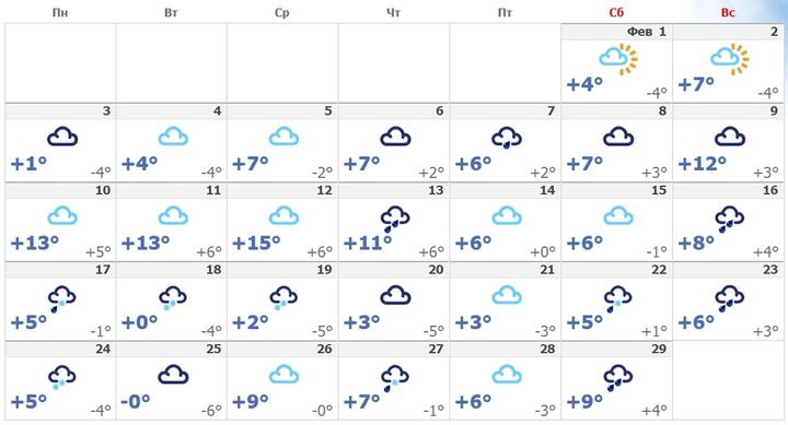
According to forecasts, snow in February is not worth the wait. Light precipitation in the form of snow at night is possible, however, they will not be able to last during the day due to stably positive temperatures. On the eve of spring, the thermometer columns will no longer fall below +5, but a decrease in wind speed is not predicted.
Read also:



 (2 ratings, average: 4,50 out of 5)
